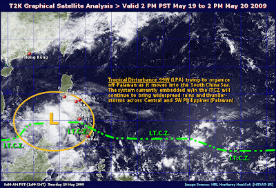
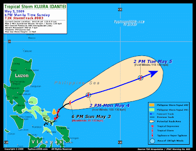
Saturday, May 30, 2009

Weather Update Dissemination for Bacolod City


Issued At: 5:00 a.m., 30 May 2009
Valid Beginning:5:00 a.m. today until 5:00 a.m. tomorrow

Synopsis:
At 2 AM today, a Low Pressure Area (LPA) was estimated based on satellite and surface data at 580 kms East of Northern Mindanao (8.9°N; 132.0°E) Monsoon trough across Northern and Central Luzon.
Forecast:
Luzon, Western Visayas and Mindanao will experience mostly cloudy skies with scattered rainshowers and thunderstorms becoming frequent rains over Southern Luzon. The rest of the country will be partly cloudy to at times cloudy skies with isolated rainshowers or thunderstorms mostly in the afternoon or evening. Light to moderate winds blowing from the North and Southwest will prevail over Northern Luzon and coming from the Southwest over the rest of the country. The coastal waters throughout the archipelago will be slight to moderate.
Source:CIMSS/PAGASA
/alb

Friday, May 29, 2009

Earthquake in the Philippines/May29, 2009


Magnitude 4.9 - NEGROS, PHILIPPINES
2009 May 29 01:15:01 UTC

Earthquake Details
Magnitude
Friday, May 29, 2009 at 01:15:01 UTC
Friday, May 29, 2009 at 09:15:01 AM at epicenter
Time of Earthquake in other Time Zones
Location
9.151°N, 122.051°E
Depth
35 km (21.7 miles) set by location program
Region
NEGROS, PHILIPPINES
Distances
140 km (85 miles) W of Dumaguete, Negros, Philippines160 km (100 miles) WNW of Dipolog, Mindanao, Philippines180 km (110 miles) SSW of Iloilo, Panay, Philippines615 km (380 miles) S of MANILA, Philippines
Location Uncertainty
horizontal +/- 11.9 km (7.4 miles); depth fixed by location program
Parameters
NST= 14, Nph= 14, Dmin=588.9 km, Rmss=0.82 sec, Gp=104°,M-type=body wave magnitude (Mb), Version=6
Source
USGS NEIC (WDCS-D)
Event ID
us2009hfag
This event has been reviewed by a seismologist.
/alb

Weather Update Dissemination for Bacolod City


Issued At: 5:00 a.m., 29 May 2009
Valid Beginning:5:00 a.m. today until 5:00 a.m. tomorrow

Synopsis:
Monsoon trough extending across Central and Northern Luzon

Forecast:
Luzon will experience mostly cloudy skies with scattered rainshowers and thunderstorms becoming frequent rains over Central Luzon .the rest of the country will be partly cloudy to at times cloudy with isolated rainshowers or thunderstorms mostly in the afternoon or evening. Light to moderate winds blowing from the southwest will prevail over the country with slight to moderate seas.

Source: pagasa/cimss

/alb

Thursday, May 28, 2009

Weather Update Dissemination for Bacolod City


Issued At: 5:00 a.m., 28 May 2009
Valid Beginning:5:00 a.m. today until 5:00 a.m. tomorrow


Synopsis:
Intertropical Convergence Zone (ITCZ) affecting Eastern Mindanao. Moderate southwesterly surface windflow prevailing over Luzon and Visayas.

Forecast:
Northern and Central Luzon and the Eastern section of Mindanao will experience mostly cloudy skies with scattered rainshowers and thunderstorms. The rest of the country will be partly cloudy to at times cloudy with isolated rainshowers or thunderstorms mostly in the afternoon or evening. Moderate winds blowing from the southwest will prevail over Luzon and Visayas with moderate seas. Elsewhere, winds will be light to moderate coming from the southwest and west with slight to moderate seas.

Source:CIMSS/PAGASA

/alb

Wednesday, May 27, 2009

Weather Update Dissemination for Bacolod City


Issued At: 5:00 a.m., 27 May 2009
Valid Beginning: 5:00 a.m. today until 5:00 a.m. tomorrow

Synopsis:
At 2:00 AM today, a Low Pressure Area (LPA) was estimated based on satellite and surface data at 400 kms North of Extreme Northern Luzon (24.6°N, 123.0°E). Intertropical Convergence Zone (ITCZ) affecting Mindanao.

Forecast:
Mindanao and Extreme Northern Luzon will experience mostly cloudy skies with scattered rainshowers and thunderstorms. The rest of the country will be partly cloudy to at times cloudy with isolated rainshowers or thunderstorms mostly in the afternoon or evening.Light to moderate winds blowing from the south to southwest will prevail over Luzon and coming from the east and southeast over the rest of the country. The coastal waters throughout the archipelago will be slight to moderate.
Source: CIMSS/PAGASA
/alb

Tuesday, May 26, 2009

Weather Update Dissemination for Bacolod City


Issued At: 5:00 a.m., 26 May 2009
Valid Beginning:5:00 a.m. today until 5:00 a.m. tomorrow

Synopsis:
Ridge of High Pressure Area (HPA) extending across Luzon.

Forecast:
The whole country will experience partly cloudy to at times cloudy skies with isolated rainshowers or thunderstorms mostly in the afternoon or evening. Light to moderate winds blowing from the east and southeast will prevail over Luzon and Visayas and coming from the east over the rest of the country. The coastal waters throughout the archipelago will be slight to moderate.
Source:CIMSS/PAGASA
/alb

Monday, May 25, 2009

Weather Update Dissemination for Bacolod City


Issued At: 5:00 a.m., 25 May 2009
Valid Beginning:5:00 a.m. today until 5:00 a.m. tomorrow

Synopsis:
Ridge of High Pressure Area (HPA) affecting Luzon and Visayas.

Forecast:
The whole country will experience partly cloudy to at times cloudy skies with isolated rainshowers or thunderstorms mostly in the afternoon or evening. Light to moderate winds blowing from the East and Southeast will prevail over Luzon and Visayas and coming from the East over Mindanao. The coastal waters throughout the archipelago will be slight to moderate.
Source: CIMSS/PAGASA
/alb

Friday, May 22, 2009

Weather Update Dissemination for Bacolod City


Issued At: 5:00 a.m., 22 May 2009
Valid Beginning: 5:00 a.m. today until 5:00 a.m. tomorrow

Synopsis:
At 2:00 a.m.,today, a Low Pressure Area (LPA) was estimated based on satellite and surface data at 380 kms West of Iba Zambales (15.5°N, 116.0°E). Intertropical Convergence Zone (ITCZ) affecting the Western sections of Central and Southern Luzon, Western Visayas and Mindanao.

Forecast:
The Western sections of Central and Southern Luzon, Western Visayas and Mindanao will experience mostly cloudy skies with scattered rainshowers and thunderstorms. The rest of the country will be partly cloudy to at times cloudy with isolated rainshowers or thunderstorms mostly in the afternoon or evening. Light to moderate winds blowing from the east and southeast will prevail over Luzon and coming from the Southwest over Western Visayas. Elswhere, winds will be light to moderate coming from the east and northeast will prevail and the coastal waters throughout the archipelago will be slight to moderate.
SOURCE: CIMSS/PAGASA
/alb

Thursday, May 21, 2009

Weather Update Dissemination for Bacolod City


Issued At:5:00 a.m., 21 May 2009
Valid Beginning: 5:00 a.m. today until 5:00 a.m. tomorrow


Synopsis:
At 2:00 AM today, a Shallow Low Pressure Area (SLPA) was estimated based on satellite and surface data at 230 kms West Northwest of Iba Zambales or 250 kms West of Dagupan City (16.3°N, 117.7°E).

Forecast:
Central Luzon and Western section of Southern Luzon will experience mostly cloudy skies with scattered rainshowers and thunderstorms. The rest of the country will be partly cloudy to at times cloudy with isolated rainshowers or thunderstorms mostly in the afternoon or evening. Light to moderate winds blowing from the southwest and southeast will prevail over Luzon and Visayas and coming from the east and southeast over the rest of the country. The coastal waters throughout the archipelago will be slight to moderate.
Source:CIMSS/PAGASA
/alb

Wednesday, May 20, 2009

Weather Update Dissemination for Bacolod City


Issued At: 5:00 a.m., 20 May 2009
Valid Beginning:5:00 a.m. today until 5:00 a.m. tomorrow

Synopsis:
At 2:00 a.m. today, an Active Low Pressure Area (ALPA) was estimated based on satellite and surface data at 320 kms Northwest of Puerto Princesa City (12.4°N 116.7°E) embedded along the Intertropical Convergence Zone (ITCZ) affecting Southern Luzon, Visayas and Mindanao.
Forecast:
Southern Luzon, Visayas and Mindanao will experience cloudy skies with scattered rainshowers and thunderstorms becoming widespread rains over Palawan and the Western sections of Visayas and Mindanao which may trigger flashfloods and landslides. Central and the rest of Southern Luzon will have mostly cloudy skies with scattered rainshowers and thunderstorms. The rest of the country will be partly cloudy to at times cloudy with isolated rainshowers or thunderstorms mostly in the afternoon or evening. Light to moderate winds blowing from the southeast will prevail over Luzon and Eastern Visayas and coming from the southwest and southeast over the rest of the country. The coastal waters throughout the archipelago will be slight to moderate.
Source:CIMSS/PAGASA
/alb

Tuesday, May 19, 2009

Weather Update Dissemination for Bacolod city


Issued At: 5:00 a.m., 19 May 2009
Valid Beginning:5:00 a.m. today until 5:00 a.m. tomorrow


Synopsis:
At 2:00 a.m. today, the Low Pressure Area (LPA) was estimated based on satellite and surface data at 60 kms West Northwest of Puerto Princesa City (10.0°N 118.2°E) embedded along the Intertropical Convergence Zone (ITCZ) affecting Southern Luzon, Visayas and Mindanao.


Forecast:
Southern Luzon, Visayas and Mindanao will experience cloudy skies with scattered rainshowers and thunderstorms becoming widespread rains over Palawan which may trigger flashfloods and landslides. The rest of the country will be partly cloudy to at times cloudy with isolated rainshowers or thunderstorms mostly in the afternoon or evening. Light to moderate winds blowing from the southeast will prevail over Luzon and coming from the east and southeast over the rest of the country. The coastal waters throughout the archipelago will be slight to moderate.

Source: PAGASA/CIMSS

/alb

Thursday, May 14, 2009

Weather Update Dissemination for Bacolod City


Issued At: 5:00 a.m., 14 May 2009
Valid Beginning:5:00 a.m. today until 5:00 a.m. tomorrow

Synopsis:
Intertropical Convergence Zone (ITCZ) affecting Mindanao.

Forecast:
Mindanao will experience mostly cloudy skies with scattered rainshowers and thunderstorms. The rest of the country will be partly cloudy to at times cloudy with isolated rainshowers or thunderstorms mostly in the afternoon or evening. Light to moderate winds blowing from the northeast will prevail over Northern Luzon and coming from the east to northeast over the rest of the country. The coastal waters throughout the archipelago will be slight to moderate.

Source: CIMSS/PAGASA
/alb

Wednesday, May 13, 2009

Weather Dissemination for Bacolod City


Issued At: 5:00 a.m., 13 May 2009
Valid Beginning:5:00 a.m. today until 5:00 a.m. tomorrow

Synopsis:
Intertropical Convergence Zone (ITCZ) affecting Visayas and Mindanao.

Forecast:
Bicol Region, Visayas and Mindanao will experience mostly cloudy skies with scattered rainshowers and thunderstorms. The rest of the country will be partly cloudy to at times cloudy with isolated rainshowers or thunderstorms mostly in the afternoon or evening.Light to moderate winds blowing from the northeast will prevail over Luzon and coming from the east to northeast over the rest of the country. The coastal waters throughout the archipelago will be slight to moderate.
Source: PAGASA
/alb

Tuesday, May 12, 2009

Weather Dissemination for Bacolod City


Issued At: 5:00 a.m., 12 May 2009
Valid Beginning:5:00 a.m. today until 5:00 a.m. tomorrow

Synopsis:
At 2 a.m. today, the Low Pressure Area (LPA) was estimated based on satellite and surface data at 680 kms Northeast of Extreme Northern Luzon (23.4°N, 127.1°E). Intertropical Convergence Zone (ITCZ) affecting Visayas and Mindanao.

Forecast:
Visayas and Mindanao will experience mostly cloudy skies with scattered rainshowers and thunderstorms. The rest of the country will be partly cloudy to at times cloudy with isolated rainshowers or thunderstorms mostly in the afternoon or evening. Light to moderate winds blowing from the east to southeast will prevail over Luzon and Visayas and coming from the northeast and east over the rest of the country. The coastal waters throughout the archipelago will be slight to moderate.
Source: PAGASA
/alb

Monday, May 11, 2009

Weather Update Dissemination for Bacolod City


Issued At: 5:00 a.m., 11 May 2009
Valid Beginning:5:00 a.m. today until 5:00 a.m. tomorrow

Synopsis:
At 2 a.m. today, the Low Pressure Area (LPA) was estimated based on satellite and surface data at 575 kms East of Extreme Northern Luzon (20.6°N, 127.3°E). Intertropical Convergence Zone (ITCZ) affecting Mindanao.

Forecast:
Mindanao will experience mostly cloudy skies with scattered rainshowers and thunderstorms. The rest of the country will be partly cloudy to at times cloudy with isolated rainshowers or thunderstorms mostly in the afternoon or evening. Moderate to occasionally strong winds blowing from the northeast will prevail over Extreme Northern Luzon and the coastal waters along this area will be moderate to occasionally rough. Elsewhere, winds will be light to moderate coming from the northeast and east with slight to moderate seas.
Source: CIMSS/PAGASA
/alb

Friday, May 8, 2009

Weather Update Dissemination for Bacolod City


Severe Weather Bulletin Number SIX
Tropical Cyclone Warning: Tropical Storm "EMONG" (Chan-hom)
Issued at 5:00 a.m., Friday, 08 May 2009
Typhoon "EMONG" has weakened into a tropical storm after crossing the mountainous terrain of Northern Luzon and is now off the coast of Isabela.
Location of Center:(as of 4:00 a.m.) 110 kms East of Tuguegarao City or 150 kms Southeast of Aparri, Cagayan
Coordinates: 17.6°N, 122.8°E
Strength: Maximum sustained winds of 95 kph near the center and gustiness of up to 120 kph
Movement: Northeast at 15 kph.
Forecast Positions/Outlook:
Saturday morning:370 kms East Northeast of Aparri, Cagayan or 300 kms East Southeast of Basco, BatanesSunday morning:570 kms East Northeast of Basco, Batanes
Monday morning:850 kms Northeast of Basco, Batanes or 190 kms East Southeast of Okinawa, Japan
Source:PAGASA/CIMSS
/alb

Thursday, May 7, 2009

Weather Dissemination for Bacolod City


TYPHOON CHAN-HOM (EMONG/02W/0902)

T2K PUBLIC ADVISORY NUMBER 013:

As of 12:00 PM PST (04:00 GMT) Thu 07 May 2009

Source: JTWC WARNING #015 (US Navy/Air Force) / T2K XTRAPOLATION


Typhoon CHAN-HOM (EMONG) gathering strength as it dangerously accelerates closer to Pangasinan-La Union Area. Pangasinan and La Union including the cities of Dagupan and San Fernando must be on full alert as it remains under serious threat from this system.


Forecast Outlook: CHAN-HOM is expected to continue moving on a generally ENE to NE track for the next 2 days, may still intensify prior to landfall. The 2-day Short-Range Forecast now shows CHAN-HOM passing over Lingayen Gulf tonight and shall make landfall over La Union between 1-3 AM tomorrow Friday May 8. It shall gradually weaken upon crossing the Cordillera Mountains Friday afternoon til Saturday and dissipate off the northeastern tip of Luzon, or in the vicinity of Northern Cagayan by Sunday morning May 10.


Time/Date: 12:00 PM PST Thu May 07 2009

Location of Center: 15.5º N Lat 118.3º E Lon

Distance 1: 220 km (120 nm) WSW of Dagupan City

MaxWinds (1-min avg): 145 kph (78 kts) near the center

Peak Wind Gusts: 170 kph (93 kts)

Saffir-Simpson Scale: Category 1

Coastal Storm Surge Height: 4-5 feet [1.2-1.7 m]

Central Pressure: 965 millibars (hPa)

Recent Movement: ENE @ 22 kph (12 kts)

General Direction: Pangasinan-La Union AreaSize (in Diameter): 665 km (360 nm) / Avg/LargeMax Sea Wave Height (near center): 19 ft (5.7 m)
Areas with Public Storm Signals (PAGASA)
Signal No. 1:Western Pangasinan, La Union, Ilocos Sur
Signal No. 2: Zambales, Tarlac, Rest of Pangasinan, Benguet, Ifugao, Mt.Province, Kalinga Apayao, Abra, Ilocos Norte
Signal No. 3: Metro Manila, Batangas, Laguna, Rizal, Oriental Mindoro, Occidental Mindoro, Lubang Island, Calamian Group of Islands, Cavite, Pampanga, Bataan, Bulacan, Northern Quezon, Aurora, Nueva Ecija, Nueva Viscaya, Quirino, Isabela, Cagayan, Babuyan Island, Batanes Group of Islands
/alb

Weather Update Dissemination for Bacolod City


Severe Weather Bulletin Number TWO
Tropical Cyclone Warning: Typhoon "EMONG" (Chan-hom)
Issued at 5:00 a.m., Thursday, 07 May 2009

"EMONG" has intensified into a typhoon as it continues to move closer to Northern Luzon.
Coordinates:15.1°N, 116.4°E
Strength: Maximum sustained winds of 120 kph near the center and gustiness of up to 150 kph
Movement: Northeast at 17 kph.

Forecast Positions/Outlook:
Friday morning:80 kms Northwest of Dagupan City or 120 kms Southwest of Vigan, Ilocos Sur

Saturday morning:180 kms East Northeast of Tuguegarao City

Sunday morning:570 kms Northeast of Tuguegarao City or 560 kms East Northeast of Aparri, Cagayan

Areas Having Public Storm Warning Signal

Signal No. 2:(60-100 kph winds)Ilocos Norte, Abra,Ilocos Sur,La Union,Benguet, Pangasinan, Zambales

Signal No. 1:Apayao, Kalinga, Mt. Province,Ifugao,Nueva Vizcaya,Quirino,Nueva Ecija, Tarlac, Pampanga,Bataan

Residents living in low lying and mountainous areas under signal # 1 and 2 are alerted against flashfloods and landslides.

The rest of Central Luzon, Southern Luzon including Metro Manila will continue to experience occasional rains.

The public and the disaster coordinating councils concerned are advised to take appropriate actions and watch for the next bulletin to be issued at 11 A.M. today.

Wednesday, May 6, 2009

Weather Update Dissemination for Bacolod City

Weather Advisory no. 01 (PAGASA)
For: Tropical Storm (Chan-Hom)
Issued at 11:00 a.m., 06 May 2009


THE TROPICAL STORM WEST OF SOUTHERN LUZON WAS ESTIMATED AT 710 KMS WEST OF MINDORO (13.5°N 113.0°E) WITH MAXIMUM SUSTAINED WINDS OF 110 KPH AND GUSTINESS OF UP TO 140 KPH. IT IS FORECAST TO MOVE NORTHEAST AT 15 KPH. THIS WEATHER DISTURBANCE IS EXPECTED TO ENTER OVER THE WESTERN BOUNDARY OF PHILIPPINE AREA OF RESPONSIBILITY BY TOMORROW MORNING. THIS TROPICAL CYCLONE IS STILL FAR TO AFFECT ANY PART OF THE COUNTRY. HOWEVER, THE ACTIVE INTERTROPICAL CONVERGENCE ZONE (ITCZ) WILL BRING SCATTERED RAINSHOWERS AND THUNDERSTORMS OVER NORTHERN AND CENTRAL LUZON BECOMING WIDESPREAD OVER THE WESTERN SECTIONS WHICH MAY TRIGGER FLASHFLOODS.

RESIDENTS IN THESE AREAS ARE ADVISED TO TAKE ALL THE NECESSARY PRECAUTIONARY MEASURES.

THE NEXT UPDATE WILL BE INCORPORATED IN THE REGULAR PUBLIC WEATHER FORECAST TO BE ISSUED AT 5:00 PM TODAY.
Source: PAGASA
/alb

Weather Update Dissemination for Bacolod City


TROPICAL STORM CHAN-HOM (PRE-EMONG/02W/0902)
T2K PUBLIC ADVISORY NUMBER 008:
As of 6:00 AM PST (22:00 GMT) Wed 06 May 2009
Source: JTWC WARNING #010 (US Navy/Air Force) / T2K XTRAPOLATION

Tropical Storm CHAN-HOM (02W/Pre-EMONG) has begun tracking ENE-ward closer to the Philippine Area of Responsibility (PAR)...nears Typhoon intensity. The coastal stretch from Ilocos Norte, La Union down to Zambales are likely to be the Area of Projected Impact, as shown on various Numerical Computer Forecast Models.

Forecast Outlook:
CHAN-HOM is expected to move on a generally ENE to NE track for the next 5 days, becoming a Category 1 Typhoon later today & shall enter the western part of the Philippine Area of Responsibility (PAR) tomorrow morning May 7 with winds of 130 kph. The 3 to 5-day Long-Range Forecast shows CHAN-HOM making landfall in between Ilocos Sur & La Union or in between La Union & Pangasinan sometime early morning of Saturday, May 9. It shall gradually weaken into a storm or depression upon crossing the Cordillera Mountains late Saturday. These window of projected paths are based on the majority of computer models but changes are still possible as the storm is still 2-days away from impact

Effects: CHAN-HOM's circulation has shrunked dramatically overnight, however, renewed cloud convection over the center has begun to build up. This storm is not yet affecting any part of Western Luzon as of this time, however, its outermost rainbands is expected to reach the area later tonight or tomorrow.


Northeast (NE) Monsoon continues to affect Northern and Eastern Luzon. .........
ITCZ
(aka. Monsoon Trough) affecting the whole Philippines. It shall bring widespread scattered rains and thunderstorms - most especially in the afternoon or evening.

Time/Date: 6:00 AM PST Wed May 06 2009
Location of Center: 13.4º N Lat 113.1º E Lon
Distance 1: 205 km (110 nm) West of P.A.R.
Distance 2: 1110 km WNW of Bacolod City
MaxWinds (1-min avg): 110 kph (60 kts) near the center
Peak Wind Gusts: 140 kph (75 kts)
Saffir-Simpson Scale:
Tropical Storm
Coastal Storm Surge Height:
1-3 feet [0.3-0.9 m]
Central Pressure: 978 millibars (hPa)
Recent Movement: ENE @ 13 kph (07 kts)
General Direction: Western Luzon
Size (in Diameter): 520 km (280 nm) /
Average
Max Sea Wave Height (near center): 18 ft (5.4 m)
/alb

Tuesday, May 5, 2009

Weather Update Dissemination for Bacolod City

TROPICAL STORM CHAN-HOM (PRE-EMONG/02W/0902)
T2K PUBLIC ADVISORY NUMBER 006:
As of 12:00 PM PST (04:00 GMT) Tue 05 May 2009
Source: JTWC WARNING #007 (US Navy/Air Force) / T2K XTRAPOLATION

Tropical Storm CHAN-HOM (02W/Pre-EMONG) now carrying winds of 100 km/hr...still drifting NNE across the South China Sea...may become a Typhoon tonight. Pangasinan, Zambales down to Metro Manila are likely to be the Areas of Projected Impact, as shown on various Numerical Computer Forecast Models.

Forecast Outlook:
CHAN-HOM is expected to move slowly NNE to NE-ward for the next 24 hours becoming a Category 1 Typhoon tonight. It shall enter the western part of the Philippine Area of Responsibility (PAR) on early Thursday morning May 7 as a 150-km/hr Typhoon.

The 2 to 5-day Long-Range Forecast shows CHAN-HOM turning more to the ENE and accelerating closer to the coast of Western Luzon. CHAN-HOM shall make landfall either over Pangasinan, Zambales or Metro Manila in Western Luzon sometime Friday morning or afternoon, May 8. It shall cross Central Luzon Friday evening until Saturday, May 9. These window of projected paths are based on the majority of computer models but changes are still possible as the storm is still 3-days away from impact

Time/Date: 12:00 PM PST Tue May 05 2009
Location of Center: 12.0º N Lat 112.0º E Lon
Distance 1: 270 km (145 nm) WNW of Pagasa Is., Spratlys
MaxWinds (1-min avg): 100 kph (55 kts) near the center
Peak Wind Gusts: 130 kph (55 kts)
Saffir-Simpson Scale: Tropical Storm
Coastal Storm Surge Height: 1-3 feet [0.3-0.9 m]
Central Pressure: 982 millibars (hPa)
Recent Movement: NNE @ 04 kph (02 kts)
General Direction: Western Luzon
Size (in Diameter): 555 km (300 nm) / Average
Max Sea Wave Height (near center): 14 ft (4.2 m)
/alb

Weather Update Dissemination for Bacolod City


TROPICAL STORM CHAN-HOM (PRE-EMONG/02W/0902)
T2K PUBLIC ADVISORY NUMBER 005:
As of 6:00 AM PST (22:00 GMT) Tue 05 May 2009
Source: JTWC WARNING #006 (US Navy/Air Force) / T2K XTRAPOLATION

Tropical Storm CHAN-HOM (02W/Pre-EMONG) gaining strength over the warm waters of the South China Sea...now drifting NNE. La Union, Pangasinan down to Metro Manila are likely to be the Areas of Projected Impact, as shown on various Numerical Computer Forecast Models.

Forecast Outlook:
CHAN-HOM is expected to move NNE to NE-ward for the next 24 hours before entering the western part of the Philippine Area of Responsibility (PAR) on early Thursday morning May 7 as a 120-km/hr Category 1 Typhoon.

The 3 to 5-day Long-Range Forecast shows CHAN-HOM turning more to the ENE and accelerating closer to the coast of Western Luzon. CHAN-HOM shall make landfall either over Pangasinan, Zambales or Metro Manila in Western Luzon sometime Friday afternoon May 8.

These window of projected paths are based on the majority of computer models but changes are still possible as the storm is still 3-days away from impact.

Effects:
CHAN-HOM's circulation continues to grow larger and improve. This storm is not yet affecting any part of Western Luzon as of this time, however, its outermost rainbands is expected to reach the area late tomorrow or early Thursday morning.

1-day rainfall accumulations of 50 up to 150 mm is possible along its rain bands...with isolated accumulations of up to 200 mm near the center of TS CHAN-HOM.

Time/Date: 6:00 AM PST Tue May 05 2009
Location of Center: 12.1º N Lat 112.4º E Lon
Distance 1: 240 km (130 nm) WNW of Pagasa Is., Spratly Is
MaxWinds (1-min avg): 85 kph (45 kts) near the center
Peak Wind Gusts: 100 kph (55 kts)
Saffir-Simpson Scale: Tropical Storm
Coastal Storm Surge Height: 1-3 feet [0.3-0.9 m]
Central Pressure: 989 millibars (hPa)
Recent Movement: NNE @ 05 kph (03 kts)
General Direction: Western LuzonSize (in Diameter): 555 km (300 nm) / Average
Max Sea Wave Height (near center): 14 ft (4.2 m)
/alb

Weather Today May 5, 2009/6:00 am


TYPHOON KUJIRA (DANTE/0901/01W)T2K PUBLIC ADVISORY NUMBER 013:
As of 6:00 AM PST (22:00 GMT) Tue 05 May 2009
Source: JTWC WARNING #011 (US Navy/Air Force) / T2K XTRAPOLATION

KUJIRA (DANTE) becomes the 1st Typhoon of 2009...now reaching Category 3 status with winds of 215 km/hr...continues to move farther away from the Philippines...threatens Iwo To area.

Forecast Outlook: KUJIRA is expected to move out of the Philippine Area of Responsibility (PAR) this afternoon and shall pass very close to Iwo To & Chichi Jima tomorrow afternoon til the evening (May 6).

Effects:
KUJIRA's main circulation remains small and very powerful. Outer and inner rainbands, eye and its eyewall remains over water and not affecting any islands at this time. squalls (aka. "Subasko") across the Eastern Bicol Region, while its inner rainbands is now over the Philippine Sea, no longer affecting Catanduanes.

1-day rainfall accumulations of 100 up to 200 mm is possible along its rain bands. The Digital Rain Gauge at the T2K Weather Station has recorded 45-hr rainfall accumlations of 246.0 mm (12 AM May 1 to 12 AM May 3)...Barometer is at 1005.6 hPa.

Time/Date: 6:00 AM PST Tue May 05 2009
Location of Center: 17.5º N Lat 132.0º E Lon
Distance 1: 940 km (507 nm) ENE of Virac, Catanduanes
MaxWinds (1-min avg): 215 kph (115 kts) near the center
Peak Wind Gusts: 260 kph (140 kts)
Saffir-Simpson Scale: Category 3
Coastal Storm Surge Height: 9-12 ft [2.7-3.9 m]
Central Pressure: 937 millibars (hPa)
Recent Movement: ENE @ 26 kph (14 kts)
General Direction: Iwo To-Chichi Jima
Size (in Diameter): 665 km (360 nm) / Average
Max Sea Wave Height (near center): 18 ft (5.4 m)
Source: T2K
/alb

Weather Today May 5, 2009


Issued At: 5:00 a.m., 05 May 2009
Valid Beginning:5:00 a.m. today until 5:00 a.m. tomorrow


Synopsis:
At 2:00 a.m., today, Typhoon "DANTE" was located based on satellite and surface data at 840 kms East Northeast of Casiguran, Aurora (17.1°N 131.0°E) with maximum sustained winds of 130 kph near the center and gustiness of up to 160 kph. It is forecast to move East Northeast at 22 kph.


Forecast:
Southern Luzon and Visayas will experience mostly cloudy skies with scattered rainshowers and thunderstorms. The rest of the country will be partly cloudy to at times cloudy with isolated rainshowers or thunderstorms mostly in the afternoon or evening. Moderate to strong winds blowing from the Northeast will prevail over Northern Luzon with moderate to rough seas. Meanwhile, light to moderate winds blowing from the Northeast to Northwest will prevail over the rest of Luzon and coming from the Southwest over Visayas and Mindanao. The coastal waters along these areas will be slight to moderate.

Source: CIMSS/PAGASA
/alb

Monday, May 4, 2009

Weather Today May 4, 2009


Time/Date: 6:00 AM PST Mon May 04 2009
Location of Center: 15.4º N Lat 127.2º E
LonDistance 1: 370 km (200 nm) NE of Virac, CatanduanesDistance
MaxWinds (1-min avg): 105 kph (58 kts) near the center
Peak Wind Gusts: 135 kph (73 kts)
Saffir-Simpson Scale: Tropical Storm
Coastal Storm Surge Height: 1-3 feet [0.3-0.9 m]
Central Pressure: 982 millibars (hPa)
Recent Movement: NE @ 11 kph (06 kts)
General Direction: Philippine Sea
Size (in Diameter): 370 km (200 nm) / Average
Max Sea Wave Height (near center): 12 ft (3.6 m)
Wunderground TrackMap (for Public): 2 AM PST Mon May 4
Source:T2K
/alb

Saturday, May 2, 2009

Weather Today May 2, 2009


Tropical Depression DANTE (94W) has started to drift NE during the past 3 hours, crossing Sorsogon...now off the east coast of Sorsogon. Moderate to heavy rains prevailing across Southern Bicol particularly Masbate, Burias-Ticao Islands, Albay & Sorsogon.*Residents and visitors along the Bicol Peninsula, Northern Samar and Southern Quezon should closely monitor the progress of DANTE.


Forecast Outlook: DANTE is now expected to take a slow NE to NNE drift for the next 12 to 24 hours, passing near the east coast of Catanduanes tonight. The 2 to 3-day Medium Range Forecast now shows DANTE accelerating ENE following the path of another system (Tropical Disturbance 95/LPA) WNW of Guam which has been moving Northward.


Time/Date: 12:00 PM PST Sat May 02 2009


Location of Center: 13.1º N Lat 124.5º E Lon


Distance 1: 55 km (30 nm) East of Sorsogon CityDistance


MaxWinds (10-min avg): 55 kph (30 kts) near the center


Peak Wind Gusts: 70 kph (38 kts)


Saffir-Simpson Scale: Tropical Depression


Coastal Storm Surge Height: 0 feet [0.0 m]


Central Pressure: 1006 millibars (hPa)


Recent Movement: NE @ 04 kph (02 kts)


General Direction: Coastal Catanduanes


Size (in Diameter): 400 km (215 nm) / Average


Max Sea Wave Height (near center): 8 ft (2.4 m)


T2K TrackMap (for Public): 12 PM PST Sat May 2J


TWC Ship Avoidance Final TrackMap: 12Z Thu Dec 18 new!


PHILIPPINE STORM SIGNAL # THREE (3) In Effect: BATANES GROUP OF ISLANDS. PHILIPPINE STORM WARNING SIGNAL # TWO (2) In Effect: METRO Now lowered: CATANDUANES.


The above areas will experience stormy weather today (with winds of up to 100 kph for #02).
PHILIPPINE STORM WARNING SIGNAL # ONE (1) In Effect: CAMARINES SUR, CAMARINES NORTE, ALBAY, SORSOGON, CATANDUANES, MASBATE, BURIAS & TICAO ISLANDS, SOUTHERN QUEZON & NORTHERN SAMAR.


Now lowered: EASTERN & WESTERN SAMAR, BILIRAN, LEYTE PROVINCES, NORTHERN CEBU, BOHOL, DINAGAT PROVINCE, SIARGAO ISLAND, SURIGAO DEL NORTE, SURIGAO DEL SUR, & AGUSAN DEL NORTE.


The above areas will have rains and winds of not more than 60 kph today. Coastal waters will be moderate to rough. Residents living in river banks, low-lying and mountainous areas under Public Storm Warning Signal Number 1 are alerted against flashfloods, mudflows, mudslides and landslides.


Source: T2K


/alb


Friday, May 1, 2009

Weather Today May 1, 2009


Severe Weather Bulletin Number FOUR
Tropical Cyclone Warning: Tropical Depression "CRISING"
Issued at 5:00 a.m., Friday, 01 May 2009

Tropical Depression "CRISING" has maintained its strength as it moved westward slowly.
Location of Center: (as of 4:00 a.m.) 280 kms West Northwest of Coron, Palawan or 310 kms North Northwest of Puerto Princesa or 635 kms WNW of Bacolod City
Coordinates: 12.5°N, 117.4°E
Strength: Maximum sustained winds of 55 kph near the center
Movement: West at 7 kph

Forecast Positions/Outlook:
Saturday morning:400 kms Northwest of Puerto Princesa CitySunday morning:540 kms West Northwest of Puerto Princesa CityMonday morning:690 kms West Northwest of Puerto Princesa City

Areas Having Public Storm Warning Signal
Signal No. 1 (30-60 kph winds) PalawanCalamian Group of Islands
Elsewhere, Public Storm Warning Signals are now lowered.


Meanwhile, a Low Pressure Area (LPA) was estimated at 70 kms Northwest of Virac, Catanduanes or 440 kms NNE of Bacolod City (14.5°N, 123.6°E).
Residents in low lying areas and near mountain slopes under storm signal #1 and the rest of Southern Luzon are alerted against possible flashfloods and landslides. The public and the disaster coordinating councils concerned are advised to take appropriate actions and watch for the next bulletin to be issued at 11 A.M. today.

Source:PAGASA/CIMSS/T2K
/alb