Thursday, April 30, 2009

Weather Today April 30, 2009,3:00PM


PAGASA
Severe Weather Bulletin Number TWO
Tropical Cyclone Warning: Tropical Depression "CRISING"
Issued at 5:00 p.m., Thursday, 30 April 2009

Tropical Depression "CRISING" has maintained its strength and remained almost stationary for the past 6 hours.
Location of Center:(as of 4:00 p.m.) 290 kms West of San Jose, Occidental Mindoro
Coordinates: 12.6°N, 118.3°E
Strength: Maximum sustained winds of 55 kph near the center
Movement: Almost stationary

Forecast Positions/Outlook:
Friday afternoon:270 kms West of San Jose, Occidental MindoroSaturday afternoon:260 kms West of San Jose, Occidental MindoroSunday afternoon:250 kms West of San Jose, Occidental Mindoro or240 kms North of Puerto Princesa City

Signal No. 1(30-60 kph winds)
PalawanCuyo IslandCalamian Group of Islands,Occidental Mindoro,Lubang Island

Meanwhile, a Low Pressure Area (LPA) was estimated in the vicinity of Albay (13.5°N, 123.6°E). Resiedents in low lying areas and near mountain slopes under storm signal #1 and the rest of Southern Luzon are alerted against possible flashfloods and landslides. The public and the disaster coordinating councils concerned are advised to take appropriate actions and watch for the next bulletin to be issued at 11 P.M. today.


TROPICAL DEPRESSION CRISING (96W)
T2K INTERMEDIATE PUBLIC ADVISORY NUMBER 001A:As of 3:00 PM PST (07:00 GMT) Thu 30 Apr 2009
Source: NOAA/JTWC SATELLITE ANALYSIS

Time/Date: 3:00 PM PST Thu Apr 30 2009
Location of Center: 12.6º N Lat 117.6º E Lon
Distance 1: 425 km (230 nm) SW of ManilaDistance
MaxWinds (10-min avg): 55 kph (30 kts) near the center
Peak Wind Gusts: 70 kph (38 kts)
Saffir-Simpson Scale: Tropical Depression
Coastal Storm Surge Height: 7 feet [2.1 m]
Central Pressure: 1000 millibars (hPa)
Recent Movement: SSE @ 05 kph (03 kt)
General Direction: South China Sea
Size (in Diameter): 250 km (135 nm) / Small
Max Sea Wave Height (near center): 8 ft (2.4 m)

PHILIPPINE STORM SIGNAL # THREE (3) In Effect: BATANES GROUP OF ISLANDS.

PHILIPPINE STORM WARNING SIGNAL # TWO (2) In Effect: METRO Now lowered: CATANDUANES.

The above areas will experience stormy weather today (with winds of up to 100 kph for #02).

PHILIPPINE STORM WARNING SIGNAL # ONE (1) In Effect: . Now lowered: EASTERN & WESTERN SAMAR, BILIRAN, LEYTE PROVINCES, NORTHERN CEBU, BOHOL, DINAGAT PROVINCE, SIARGAO ISLAND, SURIGAO DEL NORTE, SURIGAO DEL SUR, & AGUSAN DEL NORTE.

The above areas will have rains and winds of not more than 35 kph today. Coastal waters will be moderate to rough. Residents living in low-lying and mountainous areas under Public Storm Warning Signal Number 1 are alerted against flashfloods, mudflows, mudslides and landslides. -->

Tropical Depression CRISING (96W) slightly disorganized as it interacts w/ the Bicol LPA...drifting SE-ward.*Residents and visitors along Western Luzon & Western Visayas should closely monitor the progress of CRISING. **Residents of Hong Kong must take precautionary measures, as Storm Signal No. 3 is in force. Kindly check out
Hong Kong Observatory's bulletin on the passage of this storm.-->*Kindly refer to your local warnings & bulletins issued by your country's official weather agency. This advisory is intended for additional information purposes only.
+ Forecast Outlook: TD CRISING is expected to to remain almost stationary for the next 2 to 3 days due to the interaction w/ the Tropical Disturbance (LPA/94W) located over Albay or in the vicinity of Legazpi City. The 3 to 5-day long-range forecast shows TD CRISING heading on a North to NE direction and crossing Northern or Central Luzon sometime Monday, Tuesday or Wednesday (May 4-6) as a developed Tropical Storm.*Alternate Forecast Scenario: There's a possibility that AURING shall track-back to the West to WSW tomorrow and cross Bicol-Samar area on Wednesday. This scenario is likely if the developing High Pressure Steering Ridge off Taiwan strengthens and becomes the dominant factor - bringing strong surge of NE Monsoon which will steer AURING.

Weather Today April 30, 2009, 11:00am


Tropical Cyclone Update
Issued at: 11:00 a.m., 30 April 2009
The Low Pressure Area West of Mindoro has developed into a Tropical Depression and was named "CRISING".
Location of Center:(as of 10:00 a.m.) 380 kms West of San Jose, Occidental Mindoro or 244 kms WNW of Bacolod City.
Coordinates: 12.8°N, 117.2°E
Strength: Maximum sustained winds of 55 kph near the center
Movement: Quasi-stationary
Forecast Positions/Outlook:Friday morning:350 kms West of San Jose, Occidental Mindoro Saturday morning:320 kms West of San Jose, Occidental Mindoro
Sunday morning:360 kms West of San Jose, Occidental Mindoro
No Public Storm Warning Signals Raised
Meanwhile a Low Pressure Area (LPA) was estimated in the vicinity of Albay or 723 kms North of Bacolod City (13.8°N, 123.0°E). These two weather disturbances are expected to bring occasional rains over Southern Luzon and Visayas becoming frequent rains over Bicol Region, Quezon, Mindoro, Marinduque, Masbate and Samar provinces which may trigger flashfloods and landslides. The public and the disaster coordinating councils concerned are advised to take appropriate actions and watch for the next bulletin to be issued at 11 P.M. today.
Source:CIMSS/PAGASA
/alb

Weather Today April 30, 2009


Issued At: 5:00 a.m., April 30, 2009
Valid Beginning: 5:00 a.m. today until 5:00 a.m. tomorrow

Synopsis:
At 2:00 a.m. today, an Active Low Pressure Area (ALPA) was estimated based on satellite and surface data at 320 kms West of Mindoro or 704 kms of WNW Bacolod City (12.7°N, 116.8°E). Another Low Pressure Area (LPA) was estimated at 70 kms Southeast of Legaspi City or 282 kms NE of Bacolod City(12.8°N, 124.2°E).

Forecast:
Southern Luzon and Visayas will experience cloudy skies with scattered rainshowers and thunderstorms becoming widespread rains over the Bicol Region and Eastern Visayas which may trigger flashfloods and landslides. The rest of the country will have mostly cloudy skies with scattered rainshowers and thunderstorms. Moderate to strong winds blowing from the northeast will prevail over Northern, Central and Eastern Luzon and the coastal waters along these areas will be moderate to rough. Elsewhere, light to moderate winds blowing from the southwest and northwest will prevail over the rest of the country with slight to moderate seas.
Source: PAGASA/CIMSS
/alb

7:30 A.M, APR 30, 2009

SOURCE: JTWC

1) TROPICAL DISTURBANCE LOCATED NEAR 13.4N 138.5E, APPROXIMATELY 365 NM WEST OF GUAM. RECENT ANIMATED ENHANCED INFRARED SATELLITE IMAGERY SHOW THE LOW LEVEL CIRCULATION CENTER (LLCC) HAS TAKEN A MORE NORTHEASTWARD TRACK WITH AN INCREASED TRACK SPEED. MAXIMUM SUSTAINED SURFACE WINDS ARE ESTIMATED AT 15 TO 20 KNOTS.... MINIMUM SEA LEVEL PRESSURE: 1008 MB.
THE POTENTIAL FOR THE DEVELOPMENT OF A SIGNIFICANT TROPICAL CYCLONE WITHIN THE NEXT 24 HOURS REMAINS FAIR.

(2) LPA LOCATED NEAR 13.5N 117.2E, APPROXIMATELY 230 NM WEST-SOUTHWEST OF MANILA, PHILIPPINES HAS BEGUN TO INTENSIFY. IT IS CURRENTLY SHOWING THE 15-20 KNOT WINDS AROUND THE LLCC...... MAXIMUM SUSTAINED SURFACE WINDS ARE ESTIMATED AT 17 TO 22 KNOTS.
MINIMUM SEA LEVEL PRESSURE IS ESTIMATEDTO BE NEAR 1006 MB.
THE POTENTIAL FOR THE DEVELOPMENT OF A SIGNIFICANT TROPICAL CYCLONE WITHIN THE NEXT 24 HOURS IS UPGRADED TO GOOD.
/alb

Wednesday, April 29, 2009

Weather Today April 29, 2009


Issued At: 5:00 p.m., April 29, 2009
Valid Beginning:5:00 p.m. today until 5:00 p.m. tomorrow

Synopsis:
At 2:00 p.m. today, a Low Pressure Area (LPA) was estimated based on satellite and surface data at 140 kms East of Legaspi City or 398 kms WSW of Bacolod City (13.3°N, 125.3°E). Another Low Pressure Area (LPA) was estimated at 280 kms Northwest of Mindoro or 715 kms ENE of Bacolod City(14.8°N, 117.9°E).
Forecast:
Central and Southern Luzon and Visayas will experience mostly cloudy skies with scattered rainshowers and thunderstorms becoming cloudy with widespread rains over Bicol region and Central and Eastern Visayas which may trigger flashfloods and landslides. The rest of the country will be partly cloudy to at times cloudy with isolated rainshowers or thunderstorms mostly in the afternoon or evening. Moderate to strong winds blowing from the Northeast will prevail over Northern and Eastern Luzon and its coastal waters along these areas will be moderate to rough. Elsewhere, winds light to moderate coming from the Southwest to West will prevail with slight to moderate seas.
/alb
Weather Advisory no. 02
For: Low Pressure Area
Issued at 11:00 a.m., 29 April 2009

THE TWO LOW PRESSURE AREAS WAS ESTIMATED AT 220 KMS EAST OF BICOL REGION OR 466 KMS NNE OF BACOLOD CITY (13.5°N 126.0°E)AND ANOTHER AT 300 KMS SOUTHWEST OF CENTRAL LUZON OR 773 KMS WNW OF BACOLOD CITY (14.5°N 117.0°E). THESE TWO WEATHER DISTURBANCES IS EXPECTED TO BRING OCCASIONAL RAINS OVER SOUTHERN LUZON AND VISAYAS BECOMING FREQUENT OVER THE PROVINCES OF QUEZON, CAMARINES NORTE, CAMARINES SUR, CATANDUANES, ALBAY, SORSOGON, MARINDUQUE, MASBATE AND NORTHERN SAMAR WHICH MAY TRIGGER FLASHFLOODS. RESIDENTS IN THESE AREAS ARE ADVISED TO TAKE ALL THE NECESSARY PRECAUTIONARY MEASURES. THE NEXT UPDATE WILL BE INCORPORATED IN THE REGULAR PUBLIC WEATHER FORECAST TO BE ISSUED AT 5:00 PM TODAY.
Issued At: 5:00 a.m., April 29, 2009
Valid Beginning:5:00 a.m. today until 5:00 a.m. tomorrow
Synopsis:
At 2:00 a.m. today, a Low Pressure Area (LPA) was estimated based on satellite and surface data at 80 kms Northeast of Virac, Catanduanes or 499 kms NNE of Bacolod City(14.6°N, 125.0°E). Another Low Pressure Area (LPA) was estimated at 480 kms West of Mindoro or 796 kms WNW of Bacolod City(13.0°N, 116.0°E).

Forecast:
Southern Luzon and Visayas will experience mostly cloudy skies with scattered rainshowers and thunderstorms becoming cloudy with widespread rains over the Bicol Region which may trigger flashfloods and landslides. The rest of the country will be partly cloudy to at times cloudy with isolated rainshowers or thunderstorms mostly in the afternoon or evening. Moderate to strong winds blowing from the northeast will prevail over Northern and Eastern Luzon and the coastal waters along these areas will be moderate to rough. Light to moderate winds blowing from the northeast and north will prevail over the rest of the country with slight to moderate seas.

(1) THE AREA OF CONVECTION PREVIOUSLY NEAR 15.2N 123.5E, APPROXIMATELY 150 NM EAST-NORTHEAST OF MANILA, PHILIPPINES,HAS DISSIPATED AND IS NO LONGER SUSPECT FOR DEVELOPMENT OF ASIGNIFICANT TROPICAL CYCLONE WITHIN THE NEXT 24 HOURS.

2) (OUTSIDE PAR) THE AREA OF CONVECTION PREVIOUSLY LOCATED NEAR 7.3N 138.6E, IS NOW LOCATED NEAR 8.3N 138.0E, APPROXIMATELY 75 NM SOUTH OF YAP. .....THE POTENTIAL FOR THE DEVELOPMENT OF A SIGNIFICANT TROPICAL CYCLONE WITHIN THE NEXT 24 HOURS IS UPGRADED TO FAIR DUE TO THE CONTINUED CONSOLIDATION OF THE LLCC, YET WEAK ACCOMPANYING CONVECTION.
Source:CIMSS/PAGASA/JWTC
/alb

Tuesday, April 28, 2009

Weather Today April28, 2009


Issued At: 5:00 a.m., April 28, 2009
Valid Beginning:5:00 a.m. today until 5:00 a.m. tomorrow


Synopsis:
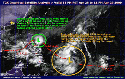
At 2 AM today, a Low Pressure Area (LPA) was estimated based on satellite and surface data at 720 kms East of Mindanao or 1185 ESE of Bacolod City (8.5°N, 133.5°E) Tail-end of a cold front affecting Luzon.

Forecast:
Luzon will experience mostly cloudy skies with scattered rains and isolated thunderstorms. The rest of the country will be partly cloudy to at times cloudy with isolated rainshowers or thunderstorms mostly in the afternoon or evening. MOderate to strong winds blowing from the northeast will prevail over Northern and Eastern Luzon and its coastal waters will be moderate to rough. Light to moderate winds blowing from the northeast and northwest will prevail over the rest of the country and the coastal waters along these areas will be slight to moderate.

Source:CIMSS/PAGASA
/alb

Monday, April 27, 2009

Weather Today April27, 2009


Satellite Image


Issued At: 5:00 a.m., April 27, 2009
Valid Beginning:5:00 a.m. today until 5:00 a.m. tomorrow


Synopsis:
At 2 a.m. today, a Low Pressure Area (LPA) was estimated based on satellite and surface data at 690 kms East of Mindanao (7.5°N, 133.4°E) embedded along the Intertropical Convergence Zone (ITCZ) affecting Mindanao. Tail-end of a cold front affecting Luzon.


Forecast:
Luzon will experience mostly cloudy skies with scattered rains and isolated thunderstorms. Mindanao will have mostly cloudy skies with scattered rainshowers and thunderstorms. The rest of the country will be partly cloudy to at times cloudy with isolated rainshowers or thunderstorms mostly in the afternoon or evening. Moderate to occasionally strong winds blowing from the northeast will prevail over Extreme Northern Luzon and its coastal waters will be moderate to occasionally rough. Light to moderate winds blowing from the southwest and southeast will prevail over the rest of Luzon and coming from the northeast and northwest over Visayas and Mindanao. The coastal waters along these areas will be slight to moderate.

Source: CIMSS/PAGASA/T2K

/alb

Sunday, April 26, 2009

Weather Today April 26, 2009


Issued At: 5:00 a.m., April 26, 2009
Valid Beginning:5:00 a.m. today until 5:00 a.m. tomorrow

Synopsis:
At 2:00 AM today, a Low Pressure Area (LPA) was estimated based on satellite and surface data at 870 kms East of Mindanao. (7.5 °N 134.9 °E). Tail- end of a cold front affecting Luzon.
Forecast:
Luzon will experience mostly cloudy skies with scattered rains and isolated thunderstorms while Mindanao will have mostly cloudy skies with scattered rainshowers and thunderstorms. The rest of the country will be partly cloudy to at times cloudy with isolated rainshowers or thunderstorms mostly in the afternoon or evening. Moderate to occasionally strong winds blowing from the Northeast will prevail over Extreme Northern Luzon and its coastal waters will be moderate to occasionally rough. Light to moderate winds blowing from the Southwest and Southeast will prevail over the rest of Luzon and coming from the Northeast to Northwest over Visayas and Mindanao with slight to moderate seas.
Source CIMSS/PAGASA
/alb

Friday, April 24, 2009

Weather Today April24, 2009


Issued At: 5:00 a.m., April 24, 2009
Valid Beginning:5:00 a.m. today until 5:00 a.m. tomorrow

Synopsis:
Tail-end of a cold front affecting Extreme Northern Luzon. Intertropical Convergence Zone (ITCZ) affecting Southern Luzon, Visayas and Mindanao.
Forecast:
Extreme Northern Luzon will experience mostly cloudy skies with scattered rainshowers while Southern Luzon, Visayas and Mindanao will have mostly cloudy skies with scattered rainshowers and thunderstorms. The rest of the country will be partly cloudy to cloudy with isolated rainshowers or thunderstorms mostly in the afternoon or evening. Moderate to occasionally strong winds blowing from the southeast will prevail over Northern and Eastern Luzon and the coastal waters along these areas will be moderate to occasionally rough. Light to moderate winds coming from the southwest and southeast will prevail over the rest of Luzon and Visayas and coming from the east and northeast over Mindanao. The coastal waters over these areas will be slight to moderate.
Tail-end of a cold front affecting Extreme Northern Luzon. Intertropical Convergence Zone (ITCZ) affecting Southern Luzon, Visayas and Mindanao.
Source: CIMSS/PAGASA
/alb
1. RECENT ANIMATED INFRARED SATELLITE IMAGERY OVER 4.8N, 142.3E SHOWS THE LOW LEVELCIRCULATION CENTER (LLCC) HAS ELONGATED AND CONVECTION HAS FRAGMENTED OVER THE PAST SIX HOURS.
2. MAXIMUMSUSTAINED SURFACE WINDS ARE ESTIMATED AT 15 TO 20 KNOTS.
3. MINIMUM SEALEVEL PRESSURE IS ESTIMATED TO BE NEAR 1007 MB. DUE TO THE DETERIORATION OF THE LLCC AND THE REDUCED AND FRAGMENTED CONVECTION, THEPOTENTIAL FOR THE DEVELOPMENT OF A SIGNIFICANT TROPICAL CYCLONE WITHIN THE NEXT 24 HOURS IS DOWNGRADED TO POOR.
Source: JWTC (10:00PM, 23APR2009)
/alb

Thursday, April 23, 2009

Weather Today April 23, 2009


As of 2:30 p.m., Apr 23, 2009
Strong LPA (93W/1008 MB) off the Caroline Islands, SSW of Guam or near 3.7N 141.7E...about 1,720 km ESE of Eastern Mindanao

Weather Today April23, 2009


Issued At: 5:00 a.m., April 23, 2009
Valid Beginning:5:00 a.m. today until 5:00 a.m. tomorrow

Synopsis:
Tail end of a cold front affecting Northern Luzon. Intertropical Convergence Zone (ITCZ) affecting Southern Luzon, Visayas and Mindanao.
Forecast:
Northern Luzon will experience mostly cloudy skies with scattered rainshowers while Southern Luzon, Visayas and Mindanao will have mostly cloudy skies with scattered rainshowers and thunderstorms. The rest of the country will be partly cloudy to cloudy with isolated rainshowers or thunderstorms mostly in the afternoon or evening.Light to moderate winds blowing from the northeast will prevail over Extreme Northern Luzon and coming from the southwest and southeast over the rest of the country. The coastal waters throughout the archipelago will be slight to moderate.
Source: CIMSS/PAGASA
/alb

Wednesday, April 22, 2009

Weather Today April 22, 2009


Above: Satellite Image as of 7:30a.m.

Issued At: 5:00 a.m., April 22, 2009
Valid Beginning:5:00 a.m. today until 5:00 a.m. tomorrow


Synopsis:
At 2:00 a.m. today, a Shallow Low Pressure Area (SLPA) was estimated based on satellite and surface data at 350 kms West Northwest of Puerto Princesa City (11.0°N 115.5°E)embedded along the Intertropical Convergence Zone (ITCZ) affecting Luzon and Visayas and Eastern Mindanao.

Forecast:
Luzon and Visayas and Eastern Mindanao will experience mostly cloudy skies with scattered rainshowers and thunderstorms becoming cloudy with widespread rains over Northern Luzon which may trigger flashfloods and landslides. The rest of the country will be partly cloudy to cloudy with isolated rainshowers or thunderstorms mostly in the afternoon or evening.Light to moderate winds blowing from the northeast will prevail over Extreme Northern Luzon and coming from the southwest and southeast over the rest of the country. The coastal waters throughout the archipelago will be slight to moderate.

Earthquake in the Philippines/Apr 22, 2009


Earthquake Details
Magnitude
4.9
Date-Time
Tuesday, April 21, 2009 at 18:47:37 UTC
Wednesday, April 22, 2009 at 02:47:37 AM at epicenter
Time of Earthquake in other Time Zones
Location
12.278°N, 126.278°E
Depth
39.4 km (24.5 miles) (poorly constrained)
Region
PHILIPPINE ISLANDS REGION
Distances
150 km (95 miles) NNE of Guiuan, Samar, Philippines180 km (110 miles) NE of Tacloban, Leyte, Philippines180 km (110 miles) E of Calbayog, Samar, Philippines630 km (390 miles) ESE of MANILA, Philippines
Location Uncertainty
horizontal +/- 8.7 km (5.4 miles); depth +/- 42.1 km (26.2 miles)
Parameters
NST= 48, Nph= 48, Dmin=>999 km, Rmss=0.7 sec, Gp= 90°,M-type=body wave magnitude (Mb), Version=Q
Source
USGS NEIC (WDCS-D)
Event ID
us2009fsb2
This event has been reviewed by a seismologist.
/alb

Tuesday, April 21, 2009

Earthquake in the Philippines/Apr 21, 2009


Earthquake Details
Magnitude
4.6
Date-Time
Tuesday, April 21, 2009 at 00:37:39 UTC
Tuesday, April 21, 2009 at 08:37:39 AM at epicenter
Time of Earthquake in other Time Zones
Location
19.242°N, 121.053°E
Depth
28.1 km (17.5 miles) (poorly constrained)
Region
BABUYAN ISLANDS REGION, PHILIPPINES
Distances
120 km (75 miles) NNE of Laoag, Luzon, Philippines165 km (100 miles) SW of Basco, Batan Islands, Philippines510 km (320 miles) N of MANILA, Philippines650 km (405 miles) S of T'AI-PEI, Taiwan
Location Uncertainty
horizontal +/- 33.9 km (21.1 miles); depth +/- 35.1 km (21.8 miles)
Parameters
NST= 13, Nph= 15, Dmin=396.3 km, Rmss=0.55 sec, Gp=202°,M-type=body wave magnitude (Mb), Version=6
Source
USGS NEIC (WDCS-D)
Event ID
us2009fsac
This event has been reviewed by a seismologist.

Weather Today April 21, 2009

Below: Satellite Image at 1:30 p.m.


Above: 11:30 a.m. Apr 21, 2009 Satellite Image

Below: 06:30 a.m., Apr 21, 2009 Satellite Image


Issued At: 5:00 a.m., April 21, 2009
Valid Beginning: 5:00 a.m. today until 5:00 a.m. tomorrow


Synopsis:
Intertropical Convergence Zone (ITCZ) affecting Southern Luzon, Visayas and Mindanao.
Forecast:
Central and Southern Luzon, Visayas and Mindanao will experience mostly cloudy skies with scattered rainshowers and thunderstorms. The rest of the country will be partly cloudy to cloudy with isolated rainshowers or thunderstorms mostly in the afternoon or evening. Light to moderate winds blowing from the Southeast and South will prevail over Luzon and Visayas and coming from the Southwest and Variable over Mindanao. The coastal waters throughout the archipelago will be slight to moderate.


Source: CIMSS/PAGASA


/alb

Earthquake in the Philippines/Apr 21, 2009


Earthquake Details
Magnitude
4.9
Date-Time
Monday, April 20, 2009 at 19:12:42 UTC
Tuesday, April 21, 2009 at 03:12:42 AM at epicenter
Time of Earthquake in other Time Zones
Location
15.435°N, 120.241°E
Depth
61.6 km (38.3 miles)
Region
LUZON, PHILIPPINES
Distances
45 km (30 miles) NW of Angeles, Luzon, Philippines70 km (45 miles) N of Olongapo, Luzon, Philippines70 km (45 miles) S of Dagupan, Luzon, Philippines120 km (75 miles) NW of MANILA, Philippines
Location Uncertainty
horizontal +/- 9.5 km (5.9 miles); depth +/- 7.9 km (4.9 miles)
Parameters
NST= 47, Nph= 47, Dmin=822.5 km, Rmss=1.07 sec, Gp=112°,M-type=body wave magnitude (Mb), Version=6
Source
USGS NEIC (WDCS-D)
Event ID
us2009frbp
This event has been reviewed by a seismologist.

Monday, April 20, 2009

Weather Today April 20, 2009


Issued At: 5:00 a.m., April 20, 2009
Valid Beginning:5:00 a.m. today until 5:00 a.m. tomorrow

Synopsis:
Tail-end of a cold front affecting Central and Southern Luzon and Visayas. Intertropical Convergence Zone (ITCZ) affecting Mindanao.
Forecast:
Central and Southern Luzon and Visayas will experience mostly cloudy skies with scattered rains and isolated thunderstorms while Mindanao including Palawan will have mostly cloudy skies with scattered rainshowers and thunderstorms. The rest of the country will be partly cloudy to at times cloudy with isolated rainshowers or thunderstorms mostly in the afternoon or evening. Light to moderate winds blowing from the southeast and southwest will prevail over Luzon and Visayas and coming from the northeast and northwest over Mindanao. The coastal waters throughout the archipelago will be slight to moderate.
Source: CIMSS/PAGASA

Sunday, April 19, 2009

Weather Today April 19, 2009


Issued At: 5:00 a.m., April 19, 2009
Valid Beginning:5:00 a.m. today until 5:00 a.m. tomorrow

Synopsis:
Tail-end of a cold front affecting Southern Luzon and Visayas. Intertropical Convergence Zone (ITCZ) affecting Visayas and Mindanao.
Forecast:
Southern Luzon and the western section of Central Luzon and Visayas will experience mostly cloudy skies with scattered rains and isolated thunderstorms, while Mindanao including Palawan will have mostly cloudy skies with scattered rainshowers and thunderstorms. The rest of the country will be partly cloudy to at times cloudy with isolated rainshowers or thunderstorms mostly in the afternoon or evening. Moderate to occasionally strong winds blowing from the Northeast and East will prevail over Extreme Northern Luzon and the coastal waters along these areas will be moderate to occasionally rough. Light to moderate winds blowing from the Southwest and Southeast will prevail over the rest of Luzon and Visayas and coming from the Northeast and Northwest over Mindanao. The coastal waters along these areas will be slight to moderate.
Source: CIMSS/PAGASA
/alb

Saturday, April 18, 2009

Weather Today April 18, 2009


Issued At: 5:00 a.m., April 18, 2009
Valid Beginning:5:00 a.m. today until 5:00 a.m. tomorrow

Synopsis:
Tail-end of a cold front affecting Southern Luzon and Visayas. Intertropical Convergence Zone (ITCZ) affecting Mindanao.

Forecast:
Southern Luzon and the western section of Central Luzon and Visayas will experience mostly cloudy skies with scattered rains and isolated thunderstorms, while Mindanao including Palawan will have mostly cloudy skies with scattered rainshowers and thunderstorms. The rest of the country will be partly cloudy to at times cloudy with isolated rainshowers or thunderstorms mostly in the afternoon or evening.Moderate to occasionally strong winds blowing from the northwest and southwest will prevail over Northern Luzon and the coastal waters along these areas will be moderate to occasionally rough. Elsewhere, winds will be light to moderate coming from the southwest and southeast will prevail with slight to moderate seas.
Source: CIMSS/PAGASA
/alb

Monday, April 13, 2009

Earthquake in the PhilippinesApr 13, 2009


Earthquake Details
Magnitude
4.7
Date-Time
Sunday, April 12, 2009 at 04:46:29 UTC
Sunday, April 12, 2009 at 12:46:29 PM at epicenter
Time of Earthquake in other Time Zones
Location
5.037°N, 127.269°E
Depth
76.4 km (47.5 miles)
Region
PHILIPPINE ISLANDS REGION
Distances
260 km (160 miles) ESE of General Santos, Mindanao, Philippines290 km (180 miles) SE of Davao, Mindanao, Philippines1260 km (780 miles) SSE of MANILA, Philippines2595 km (1610 miles) ENE of JAKARTA, Java, Indonesia
Location Uncertainty
horizontal +/- 11.6 km (7.2 miles); depth +/- 11.8 km (7.3 miles)
Parameters
NST= 40, Nph= 40, Dmin=292.5 km, Rmss=0.74 sec, Gp=112°,M-type=body wave magnitude (Mb), Version=Q
Source
USGS NEIC (WDCS-D)
Event ID
us2009fiam
This event has been reviewed by a seismologist.

Sunday, April 12, 2009

Earthquake in the Philippines/Apr 12, 2009


Earthquake Details
Magnitude
4.6
Date-Time
Saturday, April 11, 2009 at 09:50:23 UTC
Saturday, April 11, 2009 at 05:50:23 PM at epicenter
Time of Earthquake in other Time Zones
Location
13.497°N, 125.610°E
Depth
10 km (6.2 miles) set by location program
Region
PHILIPPINE ISLANDS REGION
Distances
165 km (105 miles) ESE of Pandan, Catanduanes, Philippines190 km (120 miles) NNE of Calbayog, Samar, Philippines205 km (125 miles) E of Legaspi, Luzon, Philippines515 km (320 miles) ESE of MANILA, Philippines
Location Uncertainty
horizontal +/- 13.5 km (8.4 miles); depth fixed by location program
Parameters
NST= 22, Nph= 22, Dmin=>999 km, Rmss=1.05 sec, Gp=119°,M-type=body wave magnitude (Mb), Version=7
Source
USGS NEIC (WDCS-D)
Event ID
us2009fhap
This event has been reviewed by a seismologist.
/alb

Friday, April 3, 2009

Earthquake in the Philippines/Apr3,2009

Earthquake Details
Magnitude
4.9
Date-Time
· Thursday, April 02, 2009 at 08:59:56 UTC
· Thursday, April 02, 2009 at 04:59:56 PM at epicenter
· Time of Earthquake in other Time Zones
Location
5.958°N, 126.812°E
Depth
77.9 km (48.4 miles)
Region
MINDANAO, PHILIPPINES
Distances
180 km (110 miles) SE of Davao, Mindanao, Philippines180 km (110 miles) E of General Santos, Mindanao, Philippines1155 km (710 miles) SE of MANILA, Philippines2595 km (1610 miles) ENE of JAKARTA, Java, Indonesia
Location Uncertainty
horizontal +/- 17.3 km (10.7 miles); depth +/- 13.5 km (8.4 miles)
Parameters
NST= 27, Nph= 27, Dmin=183.6 km, Rmss=0.97 sec, Gp=112°,M-type=body wave magnitude (Mb), Version=8
Source
· USGS NEIC (WDCS-D)
Event ID
us2009eya4
· This event has been reviewed by a seismologist.
/alb